
Potenza topographic map
Interactive map
Click on the map to display elevation.
About this map
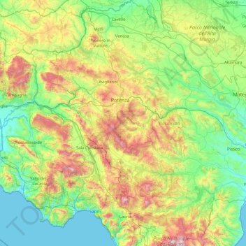
Name: Potenza topographic map, elevation, terrain.
Location: Potenza, Basilicata, Italy (39.89581 15.33497 41.14090 16.39957)
Average elevation: 521 m
Minimum elevation: 0 m
Maximum elevation: 2,186 m
The first settlement of Potentia (Potenza's original Latin name) was probably located at a lower elevation than at present, some 10 kilometres (6 miles) south of today's Potenza. The Lucani of Potentia sided against Rome's enemies during the latter's wars against the Samnites and the Bruttii. Subjugated during the 4th century BC (later gaining the status of municipium), the Potentini rebelled after the Roman defeat at Cannae in 216 BC. However, the Battle of the Metaurus marked the end of any Carthaginian aspirations in Italy and Potentia was reconquered by the Romans and reduced to the status of military colony.