
Ramsey County topographic map
Interactive map
Click on the map to display elevation.
About this map
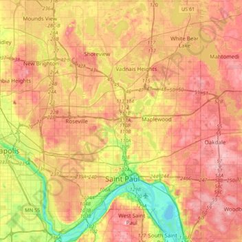
Name: Ramsey County topographic map, elevation, terrain.
Location: Ramsey County, Minnesota, United States (44.88728 -93.22784 45.12455 -92.98423)
Average elevation: 279 m
Minimum elevation: 207 m
Maximum elevation: 334 m
Other topographic maps
Click on a map to view its topography, its elevation and its terrain.
Upper Arboretum
United States > Minnesota > Rice County > Northfield
Upper Arboretum, Northfield, Rice County, Minnesota, United States
Average elevation: 292 m
Skyline
United States > Minnesota > Blue Earth County
Skyline, Blue Earth County, Minnesota, United States
Average elevation: 265 m
Maple Grove
United States > Minnesota > Hennepin County
Maple Grove, Hennepin County, Minnesota, United States
Average elevation: 278 m
Hennepin County
Hennepin County, Minnesota, United States
Average elevation: 280 m
Saint Paul
United States > Minnesota > Ramsey County > Saint Paul
Saint Paul, Ramsey County, Minnesota, United States
Average elevation: 268 m
Champlin
United States > Minnesota > Champlin
Champlin, Hennepin County, Minnesota, 55316, United States
Average elevation: 265 m