
Punakha District topographic map
Interactive map
Click on the map to display elevation.
About this map
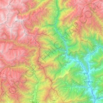
Name: Punakha District topographic map, elevation, terrain.
Location: Punakha District, Bhutan (27.46800 89.62997 27.86668 90.06790)
Average elevation: 3,210 m
Minimum elevation: 1,191 m
Maximum elevation: 5,643 m
Other topographic maps
Click on a map to view its topography, its elevation and its terrain.
Taripe
Bhutan > Trashiyangtse District > Boomdeling Gewog > Ngalimang Phanteng
Taripe, Ngalimang Phanteng, Boomdeling Gewog, Trashiyangtse District, Bhutan
Average elevation: 2,163 m
Buli
Bhutan > Zhemgang District > Nangkor Gewog > Buli
Buli, Nangkor Gewog, Zhemgang District, 00975, Bhutan
Average elevation: 2,136 m