
Saharij topographic map
Interactive map
Click on the map to display elevation.
About this map
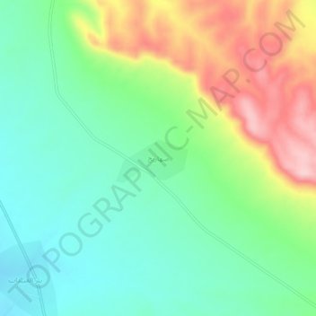
Name: Saharij topographic map, elevation, terrain.
Average elevation: 453 m
Minimum elevation: 380 m
Maximum elevation: 587 m
Other topographic maps
Click on a map to view its topography, its elevation and its terrain.
Mount Simeon Subdistrict
Mount Simeon Subdistrict, Mount Simeon District, Aleppo Governorate, Syria
Average elevation: 410 m
Ma`arrat al Atarib
Syria > Aleppo Governorate > Ma`arrat al Atarib
Ma`arrat al Atarib, Al-Atarib Subdistrict, Al-Atarib District, Aleppo Governorate, Syria
Average elevation: 357 m
Aleppo
Aleppo, Mount Simeon Subdistrict, Mount Simeon District, Aleppo Governorate, Syria
Average elevation: 413 m