
Western Area topographic map
Interactive map
Click on the map to display elevation.
About this map
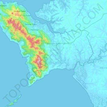
Name: Western Area topographic map, elevation, terrain.
Location: Western Area, Sierra Leone (8.09303 -13.29851 8.49962 -12.91369)
Average elevation: 49 m
Minimum elevation: -4 m
Maximum elevation: 870 m
Other topographic maps
Click on a map to view its topography, its elevation and its terrain.
Mademokai
Sierra Leone > Port Loko District > Koya Chiefdom
Mademokai, Koya Chiefdom, Port Loko District, North West Province, Sierra Leone, Sierra Leone
Average elevation: 12 m
Mopani
Sierra Leone > Southern Province > Mopani
Mopani, Pujehun District, Southern Province, Sierra Leone
Average elevation: 37 m
Sherbro Island
Sierra Leone > Southern Province
Sherbro Island, Bonthe District, Southern Province, Sierra Leone
Average elevation: 3 m
Lagula
Sierra Leone > Eastern Province > Kenema
Lagula, Kenema, Kenema District, Eastern Province, 321, Sierra Leone
Average elevation: 216 m
Armed Forces
Sierra Leone > Northern Province > Armed Forces
Armed Forces, Tonkolili District, Northern Province, Sierra Leone
Average elevation: 62 m
Gieumbu
Sierra Leone > Eastern Province > Gieumbu
Gieumbu, Kenema District, Eastern Province, Sierra Leone
Average elevation: 108 m