
Capayas Island topographic map
Interactive map
Click on the map to display elevation.
About this map
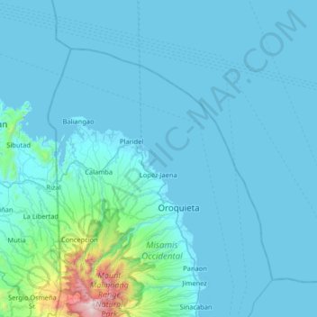
Name: Capayas Island topographic map, elevation, terrain.
Average elevation: 120 m
Minimum elevation: 0 m
Maximum elevation: 2,134 m
Other topographic maps
Click on a map to view its topography, its elevation and its terrain.
Oroquieta
Philippines > Misamis Occidental > Oroquieta
Oroquieta, Misamis Occidental, Northern Mindanao, 7207, Philippines
Average elevation: 116 m
Silanga Island
Philippines > Misamis Occidental > Oroquieta
Silanga Island, Oroquieta, Misamis Occidental, Northern Mindanao, Philippines
Average elevation: 138 m