
Thermal Lake topographic map
Interactive map
Click on the map to display elevation.
About this map
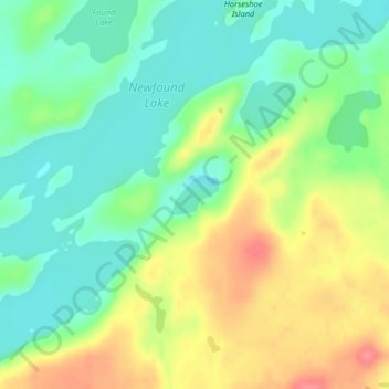
Name: Thermal Lake topographic map, elevation, terrain.
Location: Thermal Lake, Snowbank Trail, Lake County, Minnesota, USA (48.01579 -91.45753 48.01857 -91.45251)
Average elevation: 429 m
Minimum elevation: 400 m
Maximum elevation: 473 m
Other topographic maps
Click on a map to view its topography, its elevation and its terrain.
Alexandria
USA > Minnesota > Alexandria
Alexandria, Douglas County, Minnesota, 56308, USA
Average elevation: 426 m
Kettle River
Kettle River, Carlton County, Minnesota, 55757, USA
Average elevation: 367 m
Prospect Park - East River Road
USA > Minnesota > Minneapolis
Prospect Park - East River Road, Minneapolis, Hennepin County, Minnesota, USA
Average elevation: 260 m
Lake of the Woods County
Lake of the Woods County, Minnesota, USA
Average elevation: 343 m