
Trento topographic map
Interactive map
Click on the map to display elevation.
About this map
Name: Trento topographic map, elevation, terrain.
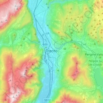
Average elevation: 786 m
Minimum elevation: 173 m
Maximum elevation: 2,137 m
The municipality of Trento stretches across a wide range of altitude levels, going from just under 200 m above sea level at the city centre, to 400 m in Povo and Cognola, to 2000 m above sea level at Monte Bondone, boroughs at higher elevation, for instance Viote, have a colder alpine climate (Dw). Urban Trento has a humid subtropical-continental climate (Cfa-Dfa) according to the Köppen climate classification. Monthly average temperatures range between 1.6 °C (January) and 23.4 °C (July). Average annual precipitation exceeds 900 mm spread out on an average of 87 days, with peaks in late spring (May–June, 90 mm monthly average in 9–10 rain days) and autumn (October–November: 100–110 mm monthly average in 7–8 days), and lows in winter (January–February, 30–40 mm monthly average in 3–4 rain days). Winters are cold to freezing, with infrequent snowfall but usual frost from mid-November to mid-March. In winter, daytime highs may not exceed 5 °C and lows may rarely dip down to -10 °C, but the former usually stand around 8°C, while the latter usually hover between -3 °C to 0 °C. Spring brings unpredictable weather with wind blowing north to south or vice-versa through the valley. Many spring days are pleasant, but the transition may be very quick, for example going from frosty mornings to 30 °C in two months. In May, it is possible to have either rainy days with daytime highs below 18 °C, or sunny days with the temperature soaring up to 30 °C. Summers are hot, sometimes sweltering, with highs getting to 35 °C at least for a week a year and more rarely to 38 °C. Summer nights can be hot as well, with overnight lows hovering around 22-24 °C (in the hilly suburbs east, north and west of Trento summer nights can be much cooler, with overnight temperature differing by up to 6 °C from the ones experienced in the city centre). Early fall is pleasant, with foliage starting around mid-October at higher elevations, late October in the uphill suburbs and in November downtown. Fall days can be humid, grey and dim, with temperatures rapidly declining through October and November. The first snowfall in the suburbs may occur as early as late November, with December and early January being the snowiest period of the year.
Other topographic maps
Click on a map to view its topography, its elevation and its terrain.
Nanno
Italy > Trentino-Alto Adige/Südtirol > Provincia di Trento > Ville d'Anaunia
Nanno, Ville d'Anaunia, Comunità della Val di Non, Provincia di Trento, Trentino-Alto Adige/Südtirol, 38093, Italy
Average elevation: 534 m
Terres
Italy > Trentino-Alto Adige/Südtirol > Provincia di Trento > Terres
Terres, Contà, Comunità della Val di Non, Provincia di Trento, Trentino-Alto Adige/Südtirol, 38019, Italy
Average elevation: 746 m