
Calagnaan Island topographic map
Interactive map
Click on the map to display elevation.
About this map
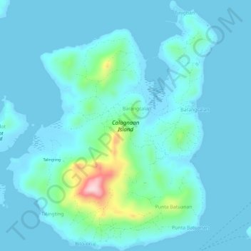
Name: Calagnaan Island topographic map, elevation, terrain.
Average elevation: 36 m
Minimum elevation: -2 m
Maximum elevation: 309 m
Other topographic maps
Click on a map to view its topography, its elevation and its terrain.
Panay
Panay island is the sixth largest island in the Philippines by area, with a total land area of 12,011 km2 (4,637 sq mi). Mount Madja-as is the highest point in Panay with an elevation of 2,117 metres (6,946 ft) above sea level, located in town of Culasi in the northern province of Antique. Central Panay…
Average elevation: 117 m
Santa Barbara
The topography of Santa Barbara varies from slightly rolling hills to almost flat or gradually inclined plains, sliced by Tigum River at its centremost, which flows from the north-west to the southeast and the Aganan River in the southern section.
Average elevation: 34 m
Guimbal
Guimbal, a coastal municipality, is located at the south-western part of Iloilo province. It is situated between the coordinates of 1250 57’ longitude, and 100 39’ latitude. It is 29 kilometres (18 mi) from Iloilo City, and has a total land area of 4,461 hectares (11,020 acres). It is only six feet above…
Average elevation: 27 m
Janiuay
Santo Tomas approximate population is 500–800. Santo Tomas (Pakol to locals) is bounded by Madong in the east, Mangil in the north-east and Danao in the south west. It is accessible by three class C feeder roads in the east, south-west and south-east. Agriculture centers around rice, corn, coffee, beans,…
Average elevation: 82 m
Dingle
On March 8, 1820, with the support of 31 cabezas de barangay of the principalía or the hispanized Christian descendants of the pre-colonial datus of Dingle and certification of the parish priest of Laglag, Fray Juan Frayle, OSA (Dingle cura párroco, 1829–1849), a petition for the re-elevation of Dingle…
Average elevation: 49 m
Bingawan
Bingawan is relatively dry from November to April and wet during the rest of the year. The maximum rain periods are not very heavy with a short dry season lasting from one to three months. The climate is influenced by the southeast monsoons, one of the principal air streams affecting the country. Local…
Average elevation: 64 m
Guimbal
Guimbal, a coastal municipality, is located at the south-western part of Iloilo province. It is situated between the coordinates of 1250 57’ longitude, and 100 39’ latitude. It is 29 kilometres (18 mi) from Iloilo City, and has a total land area of 4,461 hectares (11,020 acres). It is only six feet above…
Average elevation: 27 m
Dueñas
On March 8, 1820, with the support of 31 cabezas de barangay of the principalía of the visita of Dingle [formerly Baong], and the parish priest of Laglag, Fray Juan Raile, a petition for the re-elevation of Dingle into a pueblo was submitted to Miguel Calderón, alcalde mayor (equivalent to the present-day…
Average elevation: 50 m