
Far-Western Development Region topographic map
Interactive map
Click on the map to display elevation.
About this map
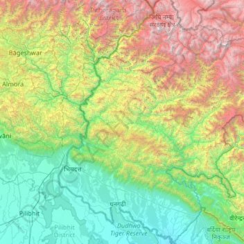
Name: Far-Western Development Region topographic map, elevation, terrain.
Location: Far-Western Development Region, Nepal (28.39432 80.05862 30.22731 81.80838)
Average elevation: 1,652 m
Minimum elevation: 139 m
Maximum elevation: 6,872 m
The Far-Western Region covered 19,539 square kilometers. It had nine districts with the regional headquarters at Dipayal, Doti District. The Far-Western Region was remote and developmentally challenged. Some 44% of people in the Far West Hills and 49% in the Himalayan districts lived below the poverty line. The region had limited basic services. The difficult topography complicated development. The region had complex socio-economic structures along with widespread gender- and caste-based discrimination. Traditional systems associated with religion, culture and customs had limited overall development.