
Milam Glacier topographic map
Interactive map
Click on the map to display elevation.
About this map
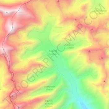
Name: Milam Glacier topographic map, elevation, terrain.
Location: Milam Glacier, Pithoragarh, Uttarakhand, India (30.45800 80.00453 30.59488 80.11819)
Average elevation: 5,223 m
Minimum elevation: 3,514 m
Maximum elevation: 7,111 m
Other topographic maps
Click on a map to view its topography, its elevation and its terrain.
Kyawa
India > Uttarakhand > Kalsi
Kyawa, Kalsi, Dehradun District, Uttarakhand, 248196, India
Average elevation: 1,652 m
Roorkee
India > Uttarakhand > Roorkee
Roorkee, Haridwar District, Uttarakhand, 247667, India
Average elevation: 270 m
Sirai
India > Uttarakhand > Tehri > Sirai
Sirai, Tehri, Tehri Garhwal, Uttarakhand, 249145, India
Average elevation: 1,021 m
Bajau
India > Uttarakhand > Bajau
Bajau, Kalsi, Dehradun, Uttarakhand, India
Average elevation: 1,689 m
Pindar Glacier
Pindar Glacier, Bageshwar, Uttarakhand, India
Average elevation: 4,447 m
Bāgeshwar
India > Uttarakhand > Bāgeshwar
Bāgeshwar, Bageshwar, Uttarakhand, 263642, India
Average elevation: 1,154 m