
Cabra Island topographic map
Interactive map
Click on the map to display elevation.
About this map
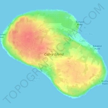
Name: Cabra Island topographic map, elevation, terrain.
Average elevation: 17 m
Minimum elevation: -1 m
Maximum elevation: 56 m
With a length of about 4.5 km (2.8 miles) and about 2.9 km (1.8 miles) at its widest, the island has a flat terrain with the highest elevation at 60.96 metres (around 200 feet). A particular rock islet near one beach is considered by locals as a symbol of the island given its shape as a cabra (Spanish for “goat”). The Cabra Island Lighthouse complex is located on Cabra Island.