
Suluan Island topographic map
Interactive map
Click on the map to display elevation.
About this map
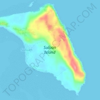
Name: Suluan Island topographic map, elevation, terrain.
Location: Suluan Island, Eastern Samar, Eastern Visayas, Philippines (10.74652 125.93768 10.77598 125.96928)
Average elevation: 12 m
Minimum elevation: 0 m
Maximum elevation: 90 m
Other topographic maps
Click on a map to view its topography, its elevation and its terrain.