
Alta Vista topographic map
Interactive map
Click on the map to display elevation.
About this map
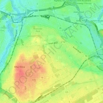
Name: Alta Vista topographic map, elevation, terrain.
Location: Alta Vista, (Old) Ottawa, Ottawa, Ontario, Canada (45.37042 -75.67790 45.42037 -75.59281)
Average elevation: 77 m
Minimum elevation: 55 m
Maximum elevation: 105 m
Other topographic maps
Click on a map to view its topography, its elevation and its terrain.
Cumberland
Canada > Ontario > Ottawa > Cumberland
Cumberland, Ottawa, Eastern Ontario, Ontario, Canada
Average elevation: 75 m