
Essequibo Islands-West Demerara topographic map
Interactive map
Click on the map to display elevation.
About this map
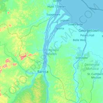
Name: Essequibo Islands-West Demerara topographic map, elevation, terrain.
Location: Essequibo Islands-West Demerara, Guyana (6.09518 -58.85587 7.11335 -58.17283)
Average elevation: 34 m
Minimum elevation: -3 m
Maximum elevation: 356 m
Other topographic maps
Click on a map to view its topography, its elevation and its terrain.
Leguan Local Government District
Guyana > Essequibo Islands-West Demerara > Leguan Local Government District
Leguan Local Government District, Essequibo Islands-West Demerara Region, Essequibo Islands-West Demerara, Guyana
Average elevation: 1 m