
Vorarlberg topographic map
Interactive map
Click on the map to display elevation.
About this map
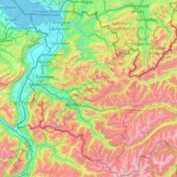
Name: Vorarlberg topographic map, elevation, terrain.
Location: Vorarlberg, Austria (46.84086 9.53075 47.59610 10.23716)
Average elevation: 1,382 m
Minimum elevation: 392 m
Maximum elevation: 3,386 m
The highest mountain is the Piz Buin, whose rocky peak of 3,312 m (10,866 ft) is surrounded by glaciers. The distance from Lake Constance and the plains of the Alpine Rhine valley across the medium altitude and high Alpine zones to the glaciers of the Silvretta range is a mere 90 km (56 mi).
Other topographic maps
Click on a map to view its topography, its elevation and its terrain.
Red Bull Ring
Red Bull Ring, Spielberg, Murtal, Styria, 824, Austria
Average elevation: 755 m
Paig
Austria > Styria > Pöls-Oberkurzheim > Paig
Paig, Pöls-Oberkurzheim, Bezirk Murtal, Styria, 8761, Austria
Average elevation: 832 m
KG Innere Stadt
KG Innere Stadt, Innere Stadt, Vienna, 1010, Austria
Average elevation: 184 m
Montafon
Austria > Vorarlberg > Gemeinde Vandans
Montafon, Sankt-Antoner-Straße, Daleu, Gemeinde Vandans, Bezirk Bludenz, Vorarlberg, 6773, Austria
Average elevation: 1,602 m
Bludenz
Austria > Vorarlberg > Bludenz
Bludenz, Bezirk Bludenz, Vorarlberg, 6700, Austria
Average elevation: 988 m
Schwarzenberg
Austria > Vorarlberg > Schwarzenberg
Schwarzenberg, Bregenz, Vorarlberg, Austria
Average elevation: 868 m
Gemeinde Hardegg
Austria > Lower Austria > Gemeinde Hardegg
Gemeinde Hardegg, Bezirk Hollabrunn, Lower Austria, Austria
Average elevation: 425 m
Krems in Kärnten
Austria > Carinthia > Krems in Kärnten
Krems in Kärnten, Spittal an der Drau, Carinthia, Austria
Average elevation: 1,707 m
Gemeinde Krems
Austria > Lower Austria > Gemeinde Krems
Gemeinde Krems, Krems, Lower Austria, Austria
Average elevation: 310 m
Wiesen
Austria > Burgenland > Wiesen
Wiesen, Bezirk Mattersburg, Burgenland, 7203, Austria
Average elevation: 375 m
Ankogel Group
Ankogel Group, Malta, Spittal an der Drau, Carinthia, 9854, Austria
Average elevation: 1,683 m
Verwall Alps
Austria > Vorarlberg > Silbertal
Verwall Alps, Silbertal, Bludenz, Vorarlberg, Austria
Average elevation: 1,957 m
Großstelzendorf
Austria > Lower Austria > Großstelzendorf
Großstelzendorf, Bezirk Hollabrunn, Lower Austria, 2013, Austria
Average elevation: 258 m
Niedere Tauern
Niedere Tauern, Sölk, Gröbming, Liezen, Styria, Austria
Average elevation: 1,207 m
Lechtal Alps
Lechtal Alps, Pfafflar, Reutte (Außerfern), Tyrol, Austria
Average elevation: 1,616 m
Stadt Kitzbühel
Austria > Tyrol > Stadt Kitzbühel
Stadt Kitzbühel, Bezirk Kitzbühel, Tyrol, 6370, Austria
Average elevation: 1,204 m
Traunsee
Austria > Upper Austria > Traunkirchen
Traunsee, Aueck, Traunkirchen, Gmunden, Upper Austria, 4801, Austria
Average elevation: 729 m
Lake Neusiedl
Austria > Burgenland > Rust
Lake Neusiedl, Ruster Bucht, Rust, Burgenland, 7071, Austria
Average elevation: 147 m
Tux Alps
Austria > Tyrol > Wattenberg
Tux Alps, Wattenberg, Innsbruck-Land, Tyrol, Austria
Average elevation: 1,555 m
Großglockner
Austria > Carinthia > Heiligenblut am Großglockner
Großglockner, Heiligenblut am Großglockner, Spittal an der Drau, Carinthia, Austria
Average elevation: 3,128 m
Firnberg
Austria > Lower Austria > Gemeinde Miesenbach
Firnberg, Gemeinde Miesenbach, Bezirk Wiener Neustadt, Lower Austria, 2761, Austria
Average elevation: 679 m