Geolocate

Meycauayan topographic map

Interactive map

Click on the map to display elevation.

About this map

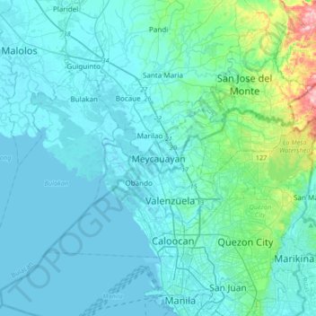
Name: Meycauayan topographic map, elevation, terrain.

Location: Meycauayan, Bulacan, Central Luzon, 3020, Philippines (14.57450 120.79716 14.89450 121.11716)

Average elevation: 27 m

Minimum elevation: -3 m

Maximum elevation: 261 m

Other topographic maps

Click on a map to view its topography, its elevation and its terrain.

Caysio

Philippines > Bulacan > Santa Maria

Average elevation: 25 m

Tawiran

Philippines > Bulacan > Obando

Average elevation: 2 m

Talacsan

Philippines > Bulacan > San Rafael

Average elevation: 30 m

Parulan

Philippines > Bulacan > Plaridel

Average elevation: 10 m

Poblacion

Philippines > Bulacan > Bustos

Average elevation: 17 m

Inaon

Philippines > Bulacan > Pulilan

Average elevation: 7 m

Dampol 2nd B

Philippines > Bulacan > Pulilan

Average elevation: 5 m

Tabang

Philippines > Bulacan > Guiguinto

Average elevation: 6 m

San Jose del Monte

Philippines > Bulacan

The elevation of the city ranges from approximately 40 to 900 meters (130 to 2,950 ft) above sea level; the relief transitions from warm lowland to cool upland as one goes eastward. This is because the city is part of the Sierra Madre mountain range. Plains and river valley flats characterize the western and…

Average elevation: 73 m

Tabon

Philippines > Bulacan > Pulilan

Average elevation: 7 m

Talampas

Philippines > Bulacan > Bustos

Average elevation: 15 m

Longos

Philippines > Bulacan > Pulilan

Average elevation: 11 m

San Jose del Monte

Philippines > Bulacan

The elevation of the city ranges from approximately 40 to 900 meters (130 to 2,950 ft) above sea level; the relief transitions from warm lowland to cool upland as one goes eastward. This is because the city is part of the Sierra Madre mountain range. Plains and river valley flats characterize the western and…

Average elevation: 73 m

San Miguel

Philippines > Bulacan

Average elevation: 36 m

Marilao

Philippines > Bulacan

Average elevation: 14 m

La Residencia

Philippines > Bulacan > Calumpit > Sergio Bayan

Average elevation: 5 m

Meycauayan

Philippines > Bulacan

Average elevation: 14 m

Angat

Philippines > Bulacan

Average elevation: 61 m

Malamig

Philippines > Bulacan > Bustos

Average elevation: 20 m

Malamig

Philippines > Bulacan > Bustos

Average elevation: 20 m

Malolos

Philippines > Bulacan

Malolos is relatively flat of about 0.81% to a gently sloping of 2.17%. The slope of the land descends towards west, southwest to southern direction. The highest land elevation is at about 6.0 m (19.7 ft) above sea level while the lowest is only 0.5 m (1 ft 8 in) below sea level. A network of natural waterways…

Average elevation: 4 m

Santa Cruz

Philippines > Bulacan

Average elevation: 3 m

San Ildefonso

Philippines > Bulacan

Average elevation: 22 m

Santa Maria

Philippines > Bulacan

The topography of Santa Maria is generally flat, however, it is becoming hilly towards the north. This area covers the barangays of Silangan, Mag-asawang Sapa, Pulong Buhangin and some parts of Balasing with landscape ranging from 8 to 18 percent slope. The rest of the barangays have a slope range from level…

Average elevation: 24 m

Meycauayan River

Philippines > Bulacan > Meycauayan > Ubihan

Average elevation: 2 m

Isla de Pulilan

Philippines > Bulacan > Plaridel > Banga Ⅱ

Average elevation: 10 m

San Miguel

Philippines > Bulacan

Average elevation: 36 m

San Jose del Monte

Philippines > Bulacan

The elevation of the city ranges from approximately 40 to 900 meters (130 to 2,950 ft) above sea level; the relief transitions from warm lowland to cool upland as one goes eastward. This is because the city is part of the Sierra Madre mountain range. Plains and river valley flats characterize the western and…

Average elevation: 73 m

San Rafael

Philippines > Bulacan

Average elevation: 32 m

San Ildefonso

Philippines > Bulacan

Average elevation: 22 m

Pugad

Philippines > Bulacan > Hagonoy

Average elevation: 2 m

Mercado

Philippines > Bulacan > Hagonoy

Average elevation: 3 m

Norzagaray

Philippines > Bulacan

Average elevation: 119 m

Malolos

Philippines > Bulacan

Malolos is relatively flat of about 0.81% to a gently sloping of 2.17%. The slope of the land descends towards west, southwest to southern direction. The highest land elevation is at about 6.0 m (19.7 ft) above sea level while the lowest is only 0.5 m (1 ft 8 in) below sea level. A network of natural waterways…

Average elevation: 4 m

Angat

Philippines > Bulacan

Average elevation: 61 m

Balagtas

Philippines > Bulacan

Average elevation: 7 m

Santa Maria

Philippines > Bulacan

The topography of Santa Maria is generally flat, however, it is becoming hilly towards the north. This area covers the barangays of Silangan, Mag-asawang Sapa, Pulong Buhangin and some parts of Balasing with landscape ranging from 8 to 18 percent slope. The rest of the barangays have a slope range from level…

Average elevation: 24 m

Angat River

Philippines > Bulacan

Average elevation: 139 m

Norzagaray

Philippines > Bulacan

Average elevation: 119 m

Santa Maria

Philippines > Bulacan

The topography of Santa Maria is generally flat, however, it is becoming hilly towards the north. This area covers the barangays of Silangan, Mag-asawang Sapa, Pulong Buhangin and some parts of Balasing with landscape ranging from 8 to 18 percent slope. The rest of the barangays have a slope range from level…

Average elevation: 24 m

Pandi

Philippines > Bulacan

Pandi is rich in many natural brooks coming from the mainland itself. In some remote areas the lands are still covered by bamboo trees that naturally thrive and multiplies. Some lands privately owned have mango plantations. In some areas that are privately owned are rock deposits being used for housing…

Average elevation: 31 m

Pulong Gubat Creek

Philippines > Bulacan > Guiguinto

Average elevation: 5 m

Ciudad de Victoria

Philippines > Bulacan > Bocaue

Average elevation: 11 m

Hinukay

Philippines > Bulacan > Baliwag

Average elevation: 11 m

Malolos

Philippines > Bulacan

Malolos is relatively flat of about 0.81% to a gently sloping of 2.17%. The slope of the land descends towards west, southwest to southern direction. The highest land elevation is at about 6.0 m (19.7 ft) above sea level while the lowest is only 0.5 m (1 ft 8 in) below sea level. A network of natural waterways…

Average elevation: 4 m

Binacod

Philippines > Bulacan

Average elevation: 3 m

Binuangan

Philippines > Bulacan > Obando

Average elevation: 2 m

Taliptip

Philippines > Bulacan > Bulakan

Average elevation: 3 m

Meycauayan River

Philippines > Bulacan > Valenzuela > Liputan

Average elevation: 3 m

Plaridel

Philippines > Bulacan

Average elevation: 9 m

Plaridel

Philippines > Bulacan

Average elevation: 9 m

Norzagaray

Philippines > Bulacan

Average elevation: 119 m

Bocaue

Philippines > Bulacan

Average elevation: 7 m

Bocaue

Philippines > Bulacan

Average elevation: 7 m

San Ildefonso

Philippines > Bulacan

Average elevation: 22 m

Robinson Homes

Philippines > Bulacan

Average elevation: 14 m

Calumpit

Philippines > Bulacan

Average elevation: 4 m

Marilao River

Philippines > Bulacan > Caloocan

Average elevation: 75 m

Balagtas

Philippines > Bulacan

Average elevation: 7 m

Encanto

Philippines > Bulacan > Angat

Average elevation: 58 m

Ipo Dam

Philippines > Bulacan > Norzagaray > Ipo

The spill level of the dam is at an elevation of 101 metres and it has seven radial floodgates. The watershed topography is characterised by mountainous terrain similar to the Angat Reservoir Watershed with moderate forest cover. The watershed has an area of about 70 square kilometers and receives an average…

Average elevation: 174 m

Malolos

Philippines > Bulacan

Malolos is relatively flat of about 0.81% to a gently sloping of 2.17%. The slope of the land descends towards west, southwest to southern direction. The highest land elevation is at about 6.0 m (19.7 ft) above sea level while the lowest is only 0.5 m (1 ft 8 in) below sea level. A network of natural waterways…

Average elevation: 4 m

Angat

Philippines > Bulacan

Average elevation: 61 m

Balagtas

Philippines > Bulacan

Average elevation: 7 m

Plaridel

Philippines > Bulacan

Average elevation: 9 m

Angat River

Philippines > Bulacan

Average elevation: 46 m

Bustos

Philippines > Bulacan

Average elevation: 19 m

Plaridel

Philippines > Bulacan

Average elevation: 9 m

San Rafael

Philippines > Bulacan

Average elevation: 32 m

Bustos

Philippines > Bulacan

Average elevation: 19 m

Santo Cristo

Philippines > Bulacan > Pulilan

Average elevation: 11 m

Malolos

Philippines > Bulacan

Malolos is relatively flat of about 0.81% to a gently sloping of 2.17%. The slope of the land descends towards west, southwest to southern direction. The highest land elevation is at about 6.0 m (19.7 ft) above sea level while the lowest is only 0.5 m (1 ft 8 in) below sea level. A network of natural waterways…

Average elevation: 4 m

Marilao

Philippines > Bulacan

Average elevation: 10 m

Pulong Gubat Creek

Philippines > Bulacan > Guiguinto

Average elevation: 4 m

Angat River

Philippines > Bulacan > Hagonoy > Iba-Ibayo

Average elevation: 4 m

San Jose del Monte

Philippines > Bulacan

The elevation of the city ranges from approximately 40 to 900 meters (130 to 2,950 ft) above sea level; the relief transitions from warm lowland to cool upland as one goes eastward. This is because the city is part of the Sierra Madre mountain range. Plains and river valley flats characterize the western and…

Average elevation: 73 m

Guiguinto

Philippines > Bulacan

Average elevation: 6 m

Guiguinto

Philippines > Bulacan

Average elevation: 6 m

Pinalagdan

Philippines > Bulacan > Paombong

Average elevation: 3 m

San Jose del Monte

Philippines > Bulacan

The elevation of the city ranges from approximately 40 to 900 meters (130 to 2,950 ft) above sea level; the relief transitions from warm lowland to cool upland as one goes eastward. This is because the city is part of the Sierra Madre mountain range. Plains and river valley flats characterize the western and…

Average elevation: 73 m

Balagtas River

Philippines > Bulacan > Balagtas

Average elevation: 6 m

Marilao

Philippines > Bulacan

Average elevation: 10 m

San Jose del Monte

Philippines > Bulacan

The elevation of the city ranges from approximately 40 to 900 meters (130 to 2,950 ft) above sea level; the relief transitions from warm lowland to cool upland as one goes eastward. This is because the city is part of the Sierra Madre mountain range. Plains and river valley flats characterize the western and…

Average elevation: 73 m

Paltao

Philippines > Bulacan > Pulilan

Average elevation: 10 m

Calumpit

Philippines > Bulacan

Average elevation: 4 m

Salambao

Philippines > Bulacan > Obando

Average elevation: 2 m

Marilao

Philippines > Bulacan

Average elevation: 10 m

Guiguinto River

Philippines > Bulacan > Guiguinto > Daungan

Average elevation: 5 m

Angat River

Philippines > Bulacan

Average elevation: 20 m

Pugad

Philippines > Bulacan > Hagonoy

Average elevation: 2 m

Hagonoy

Philippines > Bulacan

Average elevation: 1 m

Baliwag

Philippines > Bulacan

Average elevation: 16 m

Angat Dam

Philippines > Bulacan

Average elevation: 254 m

Marilao

Philippines > Bulacan

Average elevation: 10 m

Bulakan

Philippines > Bulacan

Average elevation: 4 m

Pulilan

Philippines > Bulacan

The municipality is generally of flat topography. Eleven (11) of its barangays are bounded by the Angat River. The rest are flat irrigated rice lands. Soil types vary from sandy loam to clay loam which makes the municipality suitable to a wide range of agricultural products.

Average elevation: 10 m