
Breda topographic map
Interactive map
Click on the map to display elevation.
About this map
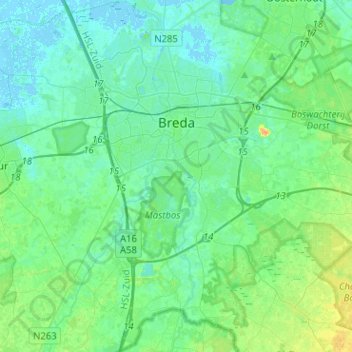
Name: Breda topographic map, elevation, terrain.
Location: Breda, North Brabant, Netherlands (51.48555 4.68601 51.64320 4.84573)
Average elevation: 7 m
Minimum elevation: -2 m
Maximum elevation: 27 m
Topographic map image of the city of Breda, March 2014. Click to enlarge.
Other topographic maps
Click on a map to view its topography, its elevation and its terrain.
's-Hertogenbosch
's-Hertogenbosch, North Brabant, Netherlands
Average elevation: 4 m
Veldhoven
Netherlands > North Brabant > Veldhoven
Veldhoven, North Brabant, Netherlands
Average elevation: 23 m
Mill
Netherlands > North Brabant > Mill en Sint Hubert
Mill, Mill en Sint Hubert, North Brabant, Netherlands
Average elevation: 14 m
Eindhoven
Netherlands > North Brabant > Eindhoven
Eindhoven, North Brabant, Netherlands
Average elevation: 20 m