
Gdansk topographic map
Interactive map
Click on the map to display elevation.
About this map
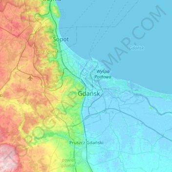
Name: Gdansk topographic map, elevation, terrain.
Location: Gdansk, Gdańsk, Pomeranian Voivodeship, Poland (54.27492 18.42950 54.44722 18.95328)
Average elevation: 49 m
Minimum elevation: -5 m
Maximum elevation: 261 m
Other topographic maps
Click on a map to view its topography, its elevation and its terrain.
Zielony staw
Poland > Pomeranian Voivodeship > Gdansk
Zielony staw, Szadółki, Jasień, Gdansk, Gdańsk, Pomeranian Voivodeship, 80-174, Poland
Average elevation: 104 m