
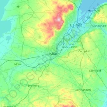
Lisburn topographic map
Interactive map
Click on the map to display elevation.
About this map
Name: Lisburn topographic map, elevation, terrain.
Average elevation: 92 m
Minimum elevation: -2 m
Maximum elevation: 471 m
Other topographic maps
Click on a map to view its topography, its elevation and its terrain.
Belfast
United Kingdom > Northern Ireland > County Antrim
Belfast, County Antrim, Northern Ireland, United Kingdom
Average elevation: 92 m
Cave Hill
United Kingdom > Northern Ireland > County Antrim > Belfast
Cave Hill, Greencastle, Belfast, County Antrim, Northern Ireland, BT15 5GL, United Kingdom
Average elevation: 172 m
Giant's Causeway
United Kingdom > Northern Ireland > County Antrim
Giant's Causeway, County Antrim, Ulster, Northern Ireland, United Kingdom
Average elevation: 26 m
Ahoghill
United Kingdom > Northern Ireland > County Antrim
Ahoghill, County Antrim, Ulster, Northern Ireland, BT42 1JZ, United Kingdom
Average elevation: 84 m
Glynn
United Kingdom > Northern Ireland > County Antrim > Glynn
Glynn, County Antrim, Northern Ireland, BT40 3HF, United Kingdom
Average elevation: 63 m
Upper Ballysillan
United Kingdom > Northern Ireland > County Antrim
Upper Ballysillan, County Antrim, Northern Ireland, United Kingdom
Average elevation: 254 m
Larne
United Kingdom > Northern Ireland > County Antrim > Larne
Larne, County Antrim, Northern Ireland, BT40 1HU, United Kingdom
Average elevation: 54 m
Belfast
United Kingdom > Northern Ireland > County Antrim
Belfast, County Antrim, Ulster, Northern Ireland, BT1 5GS, United Kingdom
Average elevation: 87 m