
Capas topographic map
Interactive map
Click on the map to display elevation.
About this map
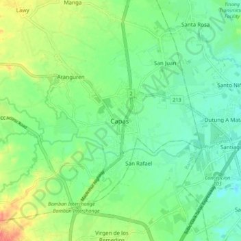
Name: Capas topographic map, elevation, terrain.
Location: Capas, Tarlac, Central Luzon, Philippines (15.29611 120.54991 15.37611 120.62991)
Average elevation: 52 m
Minimum elevation: 33 m
Maximum elevation: 87 m
Other topographic maps
Click on a map to view its topography, its elevation and its terrain.
Aranguren
Philippines > Tarlac > Capas
Aranguren, Capas, Tarlac, Central Luzon, 2315, Philippines
Average elevation: 55 m
Cutcut Ⅰ
Philippines > Tarlac > Capas
Cutcut Ⅰ, Capas, Tarlac, Central Luzon, 2315, Philippines
Average elevation: 50 m
Lawy
Philippines > Tarlac > Capas > Lawy
Lawy, Capas, Tarlac, Central Luzon, 2315, Philippines
Average elevation: 67 m
Cristo Rey
Philippines > Tarlac > Capas > Cristo Rey
Cristo Rey, Capas, Tarlac, Central Luzon, 2315, Philippines
Average elevation: 75 m