
Soissons topographic map
Interactive map
Click on the map to display elevation.
About this map
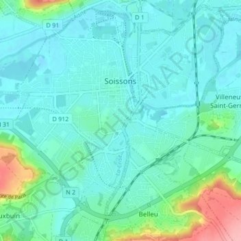
Name: Soissons topographic map, elevation, terrain.
Average elevation: 59 m
Minimum elevation: 37 m
Maximum elevation: 158 m
The Cathédrale Saint-Gervais-et-Saint-Protais de Soissons is constructed in the style of Gothic architecture. The building of the south transept was begun about 1177, and the lowest courses of the choir in 1182. The choir with its original three-storey elevation and extremely tall clerestory was completed in 1211. This was earlier than Chartres, on which the design was supposed to have been based. Work then continued into the nave until the late 13th century.