
Tư Nghĩa topographic map
Interactive map
Click on the map to display elevation.
About this map
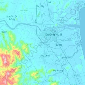
Name: Tư Nghĩa topographic map, elevation, terrain.
Location: Tư Nghĩa, Tỉnh Quảng Ngãi, Vietnam (15.01917 108.61283 15.16355 108.89981)
Average elevation: 87 m
Minimum elevation: -3 m
Maximum elevation: 1,112 m
Other topographic maps
Click on a map to view its topography, its elevation and its terrain.
Thành phố Quảng Ngãi
Thành phố Quảng Ngãi, Tỉnh Quảng Ngãi, Vietnam
Average elevation: 14 m