
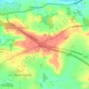
Milton Common topographic map
Interactive map
Click on the map to display elevation.
About this map
Name: Milton Common topographic map, elevation, terrain.
Average elevation: 81 m
Minimum elevation: 58 m
Maximum elevation: 105 m
Other topographic maps
Click on a map to view its topography, its elevation and its terrain.
Goring-on-Thames
United Kingdom > England > Oxfordshire > South Oxfordshire
Goring-on-Thames, South Oxfordshire, Oxfordshire, England, RG8 0EB, United Kingdom
Average elevation: 84 m
Sonning Common
United Kingdom > England > Oxfordshire > South Oxfordshire > Sonning Common
Sonning Common, South Oxfordshire, Oxfordshire, England, United Kingdom
Average elevation: 88 m
Goring-on-Thames
United Kingdom > England > Oxfordshire > South Oxfordshire
Goring-on-Thames, South Oxfordshire, Oxfordshire, England, United Kingdom
Average elevation: 87 m
Britwell Salome
United Kingdom > England > Oxfordshire > South Oxfordshire
Britwell Salome, South Oxfordshire, Oxfordshire, England, United Kingdom
Average elevation: 123 m
Sonning Eye
United Kingdom > England > Oxfordshire > South Oxfordshire > Dunsden Green
Sonning Eye, Eye and Dunsden, Dunsden Green, South Oxfordshire, Oxfordshire, England, RG4 6TN, United Kingdom
Average elevation: 51 m
Dorchester On Thames
United Kingdom > England > Oxfordshire > South Oxfordshire
Dorchester On Thames, South Oxfordshire, Oxfordshire, England, OX10 7HH, United Kingdom
Average elevation: 54 m
North Moreton
United Kingdom > England > Oxfordshire > South Oxfordshire
North Moreton, South Oxfordshire, Oxfordshire, England, United Kingdom
Average elevation: 60 m
Cholsey
United Kingdom > England > Oxfordshire > South Oxfordshire
Cholsey, South Oxfordshire, Oxfordshire, England, United Kingdom
Average elevation: 67 m
Thame
United Kingdom > England > Oxfordshire > South Oxfordshire
Thame, South Oxfordshire, Oxfordshire, England, United Kingdom
Average elevation: 74 m
Didcot
United Kingdom > England > Oxfordshire > South Oxfordshire
Didcot, South Oxfordshire, Oxfordshire, England, United Kingdom
Average elevation: 61 m
Woodcote
United Kingdom > England > Oxfordshire > South Oxfordshire
Woodcote, South Oxfordshire, Oxfordshire, England, United Kingdom
Average elevation: 136 m
Wallingford
United Kingdom > England > Oxfordshire > South Oxfordshire > Crowmarsh Gifford
Wallingford, Crowmarsh Gifford, South Oxfordshire, Oxfordshire, England, United Kingdom
Average elevation: 51 m
South Oxfordshire
United Kingdom > England > Oxfordshire > South Oxfordshire
South Oxfordshire, Oxfordshire, England, United Kingdom
Average elevation: 97 m
Henley-on-Thames
United Kingdom > England > Oxfordshire > South Oxfordshire
Henley-on-Thames, South Oxfordshire, Oxfordshire, England, RG9 2AN, United Kingdom
Average elevation: 78 m