
Aileu topographic map
Interactive map
Click on the map to display elevation.
About this map
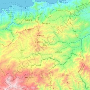
Name: Aileu topographic map, elevation, terrain.
Location: Aileu, Timor oriental (-8.85042 125.44689 -8.55917 125.81771)
Average elevation: 862 m
Minimum elevation: -1 m
Maximum elevation: 2,471 m
Other topographic maps
Click on a map to view its topography, its elevation and its terrain.
Oelete
Timor oriental > Oekusi-Ambenu > Baoknana > Oelete
Oelete, Baoknana, Nitibe, Oekusi-Ambenu, Timor oriental
Average elevation: 56 m
Lakonakbesik
Timor oriental > Cova Lima > Lakonakbesik
Lakonakbesik, Cova Lima, Timor oriental
Average elevation: 42 m