
Dane County topographic map
Interactive map
Click on the map to display elevation.
About this map
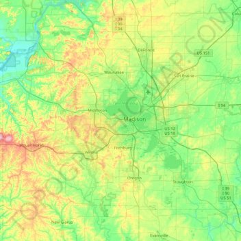
Name: Dane County topographic map, elevation, terrain.
Location: Dane County, Wisconsin, USA (42.84515 -89.83857 43.29416 -89.00883)
Average elevation: 289 m
Minimum elevation: 218 m
Maximum elevation: 477 m
Other topographic maps
Click on a map to view its topography, its elevation and its terrain.
Burnham Park
Burnham Park, Milwaukee, Milwaukee County, Wisconsin, USA
Average elevation: 201 m
James Madison Park
James Madison Park, Madison, Dane County, Wisconsin, USA
Average elevation: 263 m
Anchor Island
Anchor Island, Town of Oma, Iron County, Wisconsin, USA
Average elevation: 462 m
Adams Beach
USA > Wisconsin > Adams Beach
Adams Beach, Town of Belle Plaine, Shawano County, Wisconsin, 54933, USA
Average elevation: 249 m