
Sankt Veit an der Glan topographic map
Interactive map
Click on the map to display elevation.
About this map
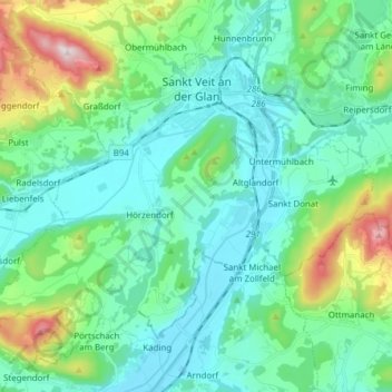
Name: Sankt Veit an der Glan topographic map, elevation, terrain.
Average elevation: 591 m
Minimum elevation: 450 m
Maximum elevation: 1,116 m
Other topographic maps
Click on a map to view its topography, its elevation and its terrain.
Zmuln
Austria > Carinthia > Bezirk Sankt Veit an der Glan > Zweikirchen
Zmuln, Zweikirchen, Liebenfels, Bezirk Sankt Veit an der Glan, Carinthia, 9556, Austria
Average elevation: 576 m
Schmieddorf
Austria > Carinthia > Bezirk Sankt Veit an der Glan > Brückl
Schmieddorf, Brückl, Bezirk Sankt Veit an der Glan, Carinthia, 9371, Austria
Average elevation: 708 m
Friesach
Austria > Carinthia > Bezirk Sankt Veit an der Glan
Friesach, Bezirk Sankt Veit an der Glan, Carinthia, 9360, Austria
Average elevation: 1,044 m