
Make a donation
São José dos Campos topographic map
Click on the map to display elevation.
Make a donation
São José dos Campos
Highlands predominate in the northern region of the municipality with altitudes ranging from 660 to 975 m (2,165 to 3,199 ft). The northern border of the municipality lies over the Serra da Mantiqueira Mountains (Mantiqueira Range), with some peaks reaching over 2000 meters (6500 ft.). The highest point in the municipality is known as 'Pico do Selado' at an altitude of 2082 meters.
Make a donation
About this map
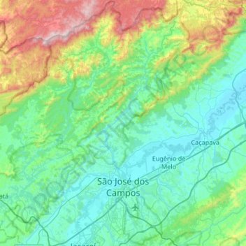
Name: São José dos Campos topographic map, elevation, terrain.
Average elevation: 824 m
Minimum elevation: 535 m
Maximum elevation: 2,002 m
Make a donation
Other topographic maps
Click on a map to view its topography, its elevation and its terrain.
Ilha Sumítica
Brazil > São Paulo > Região Metropolitana do Vale do Paraíba e Litoral Norte > Ilhabela
Average elevation: 1 m
Morro do Pico Agudo
Brazil > São Paulo > Região Metropolitana do Vale do Paraíba e Litoral Norte > Paraibuna
Average elevation: 1,056 m
Ilha Sumítica
Brazil > São Paulo > Região Metropolitana do Vale do Paraíba e Litoral Norte > Ilhabela
Average elevation: 1 m
Praça Barão do Rio Branco
Brazil > São Paulo > Região Metropolitana do Vale do Paraíba e Litoral Norte > Jacareí
Average elevation: 581 m
Serra do Roncador
Brazil > São Paulo > Região Metropolitana do Vale do Paraíba e Litoral Norte > Monteiro Lobato
Average elevation: 846 m
Make a donation
Ilha Sumítica
Brazil > São Paulo > Região Metropolitana do Vale do Paraíba e Litoral Norte > Ilhabela
Average elevation: 1 m
Paiol Grande
Brazil > São Paulo > Região Metropolitana do Vale do Paraíba e Litoral Norte > São Bento do Sapucaí
Average elevation: 1,339 m
São José dos Campos
Brazil > São Paulo > Região Metropolitana do Vale do Paraíba e Litoral Norte
In the urban area, there are rolling plateaus and hills. The lowest elevation in the city (and also in the municipality) is found in the Paraíba do Sul River, at a mean elevation of 550 m.
Average elevation: 634 m
Rio Paraíba do Sul
Brazil > São Paulo > Região Metropolitana do Vale do Paraíba e Litoral Norte > Guaratinguetá
Average elevation: 546 m
Make a donation