
Make a donation
Itapecerica da Serra topographic map
Click on the map to display elevation.
Make a donation
Itapecerica da Serra
Itapecerica da Serra (Portuguese pronunciation: [itapeˈsɛɾikɐ dɐ ˈsɛʁɐ]) is a municipality in the Brazilian state of São Paulo. It is part of the Metropolitan Region of São Paulo. The population is 177,662 (2020 est.) in an area of 150.74 km2 (58.20 sq mi). It is located 23 miles southwest of São Paulo and at an altitude of 920 m (3,020 ft) above sea level. The name Itapecerica is believed to come from the Tupi language for slippery stone, and da Serra means of the Mountains in Portuguese.
Make a donation
About this map
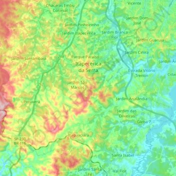
Name: Itapecerica da Serra topographic map, elevation, terrain.
Average elevation: 819 m
Minimum elevation: 728 m
Maximum elevation: 1,010 m
Make a donation
Other topographic maps
Click on a map to view its topography, its elevation and its terrain.
Praça Tenente Roberto Osaki
Brazil > São Paulo > Região Metropolitana de São Paulo > Osasco
Average elevation: 731 m
São Paulo
Brazil > São Paulo > Região Metropolitana de São Paulo > São Paulo
São Paulo is in Southeastern Brazil, in southeastern São Paulo State, approximately halfway between Curitiba and Rio de Janeiro. The city is on a plateau placed beyond the Serra do Mar (Portuguese for "Sea Range" or "Coastal Range"), itself a component of the vast region known as the Brazilian Highlands,…
Average elevation: 785 m
Sitio Borda da Mata
Brazil > São Paulo > Região Metropolitana de São Paulo > Franco da Rocha
Average elevation: 793 m
Praça Bartolomeu de Messina
Brazil > São Paulo > Região Metropolitana de São Paulo > São Paulo
Average elevation: 790 m
Make a donation
Santo André
Brazil > São Paulo > Região Metropolitana de São Paulo > Santo André
Average elevation: 776 m
São Bernardo do Campo
Brazil > São Paulo > Região Metropolitana de São Paulo > São Bernardo do Campo
Average elevation: 760 m