
Srirangapatna topographic map
Interactive map
Click on the map to display elevation.
About this map
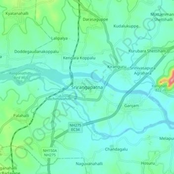
Name: Srirangapatna topographic map, elevation, terrain.
Average elevation: 693 m
Minimum elevation: 665 m
Maximum elevation: 824 m
Srirangapatna is at 12°25′N 76°42′E / 12.41°N 76.7°E / 12.41; 76.7. It has an average elevation of 679 metres (2227 feet). Srirangapatna Sangama is the confluence of the three holy streams creating the island. Located 27 km upstream from the town is the spectacular Shivanasamudra Falls, the second biggest waterfall in India and the 16th largest in the world.
Other topographic maps
Click on a map to view its topography, its elevation and its terrain.
Ganjam
India > Karnataka > Srirangapattana taluk > Ganjam
Ganjam, Srirangapattana taluk, Mandya district, Karnataka, 570020, India
Average elevation: 684 m