
Uttar Pradesh topographic map
Interactive map
Click on the map to display elevation.
About this map
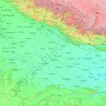
Name: Uttar Pradesh topographic map, elevation, terrain.
Location: Uttar Pradesh, India (23.87063 77.08388 30.40638 84.63451)
Average elevation: 954 m
Minimum elevation: 47 m
Maximum elevation: 7,878 m
Uttar Pradesh, with a total area of 243,290 square kilometres (93,935 sq mi), is India's fourth-largest state in terms of land area and is roughly of same size as United Kingdom. It is situated on the northern spout of India and shares an international boundary with Nepal. The Himalayas border the state on the north, but the plains that cover most of the state are distinctly different from those high mountains. The larger Gangetic Plain region is in the north; it includes the Ganges-Yamuna Doab, the Ghaghra plains, the Ganges plains and the Terai. The smaller Vindhya Range and plateau region are in the south. It is characterised by hard rock strata and a varied topography of hills, plains, valleys and plateaus. The Bhabhar tract gives place to the terai area which is covered with tall elephant grass and thick forests interspersed with marshes and swamps. The sluggish rivers of the bhabhar deepen in this area, their course running through a tangled mass of thick undergrowth. The terai runs parallel to the bhabhar in a thin strip. The entire alluvial plain is divided into three sub-regions. The first in the eastern tract consisting of 14 districts which are subject to periodical floods and droughts and have been classified as scarcity areas. These districts have the highest density of population which gives the lowest per capita land. The other two regions, the central and the western, are comparatively better with a well-developed irrigation system. They suffer from waterlogging and large-scale user tracts. In addition, the area is fairly arid. The state has more than 32 large and small rivers; of them, the Ganga, Yamuna, Saraswati, Sarayu, Betwa, and Ghaghara are larger and of religious importance in Hinduism.
Other topographic maps
Click on a map to view its topography, its elevation and its terrain.
Hyderabad
India > Telangana > Bahadurpura mandal
Hyderabad, Bahadurpura mandal, Hyderabad District, Telangana, India
Average elevation: 549 m
gehunlad
India > Uttarakhand > Chaubatta Khal
gehunlad, Chaubatta Khal, Pauri Garhwal District, Uttarakhand, India
Average elevation: 1,625 m
Thanjavur
India > Tamil Nadu > Thanjavur
Thanjavur, Thanjavur District, Tamil Nadu, 613001, India
Average elevation: 49 m
Anaikatti
India > Tamil Nadu > Coimbatore North
Anaikatti, Mannarkad, Palakkad District, Kerala, 678741, India
Average elevation: 623 m
Pune
India > Maharashtra > Pune City > Pune
Pune, Pune City, Pune District, Maharashtra, 411001, India
Average elevation: 641 m
Surat
India > Gujarat > Katargam Taluka > Surat
Surat, Katargam Taluka, Surat, Gujarat, 395001, India
Average elevation: 11 m
Delhi
India > Delhi > Kotwali Tehsil
Delhi, Kotwali Tehsil, Central Delhi, Delhi, 110006, India
Average elevation: 216 m
Bengaluru
India > Karnataka > Bangalore North
Bengaluru, Bangalore North, Bengaluru Urban District, Karnataka, India
Average elevation: 881 m
Shakarpur
India > Delhi > Gandhi Nagar Tehsil
Shakarpur, Gandhi Nagar Tehsil, East Delhi District, Delhi, India
Average elevation: 206 m
Clappana
India > Kerala > Karunagappally
Clappana, Karunagappally, Kollam District, Kerala, 690525, India
Average elevation: 5 m
Dahej
India > Gujarat > Vagra Taluka
Dahej, Vagra Taluka, Bharuch District, Gujarat, 393125, India
Average elevation: 6 m
Siliguri
India > West Bengal > Siliguri Subdivsion
Siliguri, Siliguri Subdivsion, Darjeeling District, West Bengal, India
Average elevation: 121 m
Warud
India > Maharashtra > Buldhana
Warud, Buldhana, Buldhana District, Maharashtra, India
Average elevation: 594 m
Naula
India > Uttarakhand > Bhanoli
Naula, Bhanoli, Almora District, Uttarakhand, India
Average elevation: 1,562 m
Rajmachi Fort
India > Maharashtra > Mawal > Udhewadi
Rajmachi Fort, Udhewadi, Mawal, Pune District, Maharashtra, India
Average elevation: 501 m
Malhargad Fort
India > Maharashtra > Purandhar
Malhargad Fort, Malhargad Walking Path, Purandhar, Pune District, Maharashtra, India
Average elevation: 822 m
Visapur Fort
India > Maharashtra > Mawal > Patan
Visapur Fort, Bhatrishi peak, Patan, Mawal, Pune District, Maharashtra, 410401, India
Average elevation: 818 m
Dadholi
India > Uttarakhand > Dwarahat
Dadholi, Dwarahat, Almora District, Uttarakhand, 263654, India
Average elevation: 1,449 m
Sinhagad Vikas Udyan
India > Maharashtra > Pune
Sinhagad Vikas Udyan, Vadgaon Budruk, Pune, Pune District, Maharashtra, 411051, India
Average elevation: 580 m
Asundi
India > Karnataka > Bellary taluk
Asundi, Bellary taluk, Ballari District, Karnataka, India
Average elevation: 419 m
Mandi
India > Himachal Pradesh > Mandi
Mandi, Mandi District, Himachal Pradesh, 175001, India
Average elevation: 1,273 m
Kanyakumari district
Kanyakumari district, Tamil Nadu, India
Average elevation: 226 m
Bhatwari
Bhatwari, Uttarkashi District, Uttarakhand, India
Average elevation: 4,570 m
Musi River
Musi River, Hyderabad, Uppal mandal, Medchal–Malkajgiri, Telangana, 5000036, India
Average elevation: 490 m
Panvel
India > Maharashtra > Panvel > Panvel
Panvel, Raigad, Maharashtra, 410206, India
Average elevation: 75 m
saraikhet
India > Uttarakhand > Dhoomakot
saraikhet, Dhoomakot, Pauri Garhwal District, Uttarakhand, India
Average elevation: 1,861 m
Dudori
India > Uttarakhand > Syalde > Kaljipa
Dudori, Kaljipa, Syalde, Almora District, Uttarakhand, 263665, India
Average elevation: 1,564 m
Vairavanpatti
India > Tamil Nadu > Thiruppathur
Vairavanpatti, Thiruppathur, Sivagangai District, Tamil Nadu, 630207, India
Average elevation: 103 m
Chennai
India > Tamil Nadu > Chennai
Chennai, Chennai District, Tamil Nadu, India
Average elevation: 8 m
Vadodara
India > Gujarat > Vadodara Taluka
Vadodara, Vadodara Taluka, Vadodara District, Gujarat, 390001, India
Average elevation: 36 m
Tung Fort
India > Maharashtra > Mawal
Tung Fort, Mawal, Pune District, Maharashtra, India
Average elevation: 733 m
Torna Fort
India > Maharashtra > Velhe
Torna Fort, Rajgad - Torna trail, Velhe, Pune District, Maharashtra, 412212, India
Average elevation: 1,013 m
Arani
India > Tamil Nadu > Arani
Arani, Tiruvannamalai District, Tamil Nadu, 632300, India
Average elevation: 143 m
Jorasi
India > Madhya Pradesh > Dabra Tahsil
Jorasi, Dabra Tahsil, Gwalior District, Madhya Pradesh, India
Average elevation: 256 m
Yalpi
India > Karnataka > Bellary taluk
Yalpi, Bellary taluk, Ballari District, Karnataka, India
Average elevation: 419 m