
Sakleshpur topographic map
Interactive map
Click on the map to display elevation.
About this map
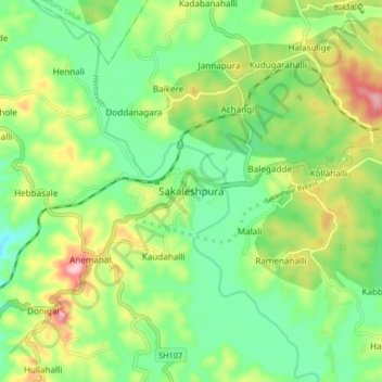
Name: Sakleshpur topographic map, elevation, terrain.
Average elevation: 924 m
Minimum elevation: 856 m
Maximum elevation: 1,043 m
Sakleshpur is located at 12°53′35″N 75°43′30″E / 12.893°N 75.725°E / 12.893; 75.725. It has an average elevation of 932 m (3,058 ft) above mean sea level.
Other topographic maps
Click on a map to view its topography, its elevation and its terrain.
Kadumane
India > Karnataka > Sakaleshapura taluk
Kadumane, Sakaleshapura taluk, Hassan District, Karnataka, India
Average elevation: 949 m
Ichalapura
India > Karnataka > Sakaleshapura taluk
Ichalapura, Sakaleshapura taluk, Hassan District, Karnataka, 573214, India
Average elevation: 917 m
Bisle Ghat View Point
India > Karnataka > Sakaleshapura taluk > Arani > Bisale
Bisle Ghat View Point, SH85, Bisale, Arani, Sakaleshapura taluk, Hassan District, Karnataka, 573123, India
Average elevation: 641 m
Kyanahalli
India > Karnataka > Sakaleshapura taluk
Kyanahalli, Sakaleshapura taluk, Hassan District, Karnataka, India
Average elevation: 909 m