
Narela topographic map
Interactive map
Click on the map to display elevation.
About this map
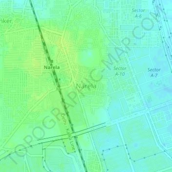
Name: Narela topographic map, elevation, terrain.
Location: Narela, Narela Tehsil, North Delhi, Delhi, 110040, India (28.83261 77.08184 28.85261 77.10184)
Average elevation: 217 m
Minimum elevation: 211 m
Maximum elevation: 222 m
Other topographic maps
Click on a map to view its topography, its elevation and its terrain.
Sector 30
India > Delhi > Narela Tehsil
Sector 30, Rohini, Narela Tehsil, North Delhi District, Delhi, India
Average elevation: 216 m
Sector 32
India > Delhi > Narela Tehsil
Sector 32, Rohini, Narela Tehsil, North Delhi District, Delhi, India
Average elevation: 216 m
Sector 29
India > Delhi > Narela Tehsil
Sector 29, Rohini, Narela Tehsil, North Delhi District, Delhi, India
Average elevation: 217 m
Bawana
India > Delhi > Narela Tehsil
Bawana, Narela Tehsil, North Delhi District, Delhi, 110039, India
Average elevation: 219 m
Narela Industrial Complex
India > Delhi > Narela Tehsil
Narela Industrial Complex, Narela Tehsil, North Delhi, Delhi, India
Average elevation: 214 m