
West Papua topographic map
Interactive map
Click on the map to display elevation.
About this map
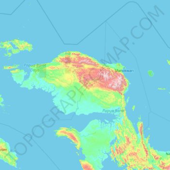
Name: West Papua topographic map, elevation, terrain.
Location: West Papua, Indonesia (-3.94424 130.34253 1.17576 135.46253)
Average elevation: 113 m
Minimum elevation: -3 m
Maximum elevation: 2,719 m
Other topographic maps
Click on a map to view its topography, its elevation and its terrain.
Pulau Salawati
Indonesia > West Papua > Sorong
Pulau Salawati, Sorong, West Papua, Indonesia
Average elevation: 43 m