
Magueija topographic map
Interactive map
Click on the map to display elevation.
About this map
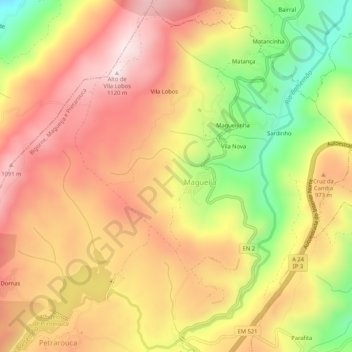
Name: Magueija topographic map, elevation, terrain.
Average elevation: 901 m
Minimum elevation: 601 m
Maximum elevation: 1,120 m
Other topographic maps
Click on a map to view its topography, its elevation and its terrain.
Bigorne
Portugal > Norte > Bigorne, Magueija e Pretarouca > Bigorne
Bigorne, Bigorne, Magueija e Pretarouca, Lamego, Viseu, Douro, Norte, Portugal
Average elevation: 961 m
Rio Balsemão
Portugal > Norte > Bigorne, Magueija e Pretarouca
Rio Balsemão, Bigorne, Magueija e Pretarouca, Lamego, Viseu, Douro, Norte, Portugal
Average elevation: 939 m