
Colfax County topographic map
Interactive map
Click on the map to display elevation.
About this map
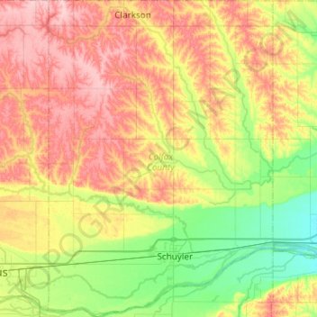
Name: Colfax County topographic map, elevation, terrain.
Location: Colfax County, Nebraska, United States (41.37687 -97.25316 41.74590 -96.90434)
Average elevation: 452 m
Minimum elevation: 391 m
Maximum elevation: 531 m
Other topographic maps
Click on a map to view its topography, its elevation and its terrain.
Omaha
United States > Nebraska > Douglas County > Omaha
Omaha, Douglas County, Nebraska, 68183, United States
Average elevation: 339 m
Omaha
United States > Nebraska > Douglas County
Omaha, Douglas County, Nebraska, United States
Average elevation: 338 m