
Altiplano topographic map
Interactive map
Click on the map to display elevation.
Altiplano
The Altiplano is noted for hypoxic air caused by very high elevation.
About this map
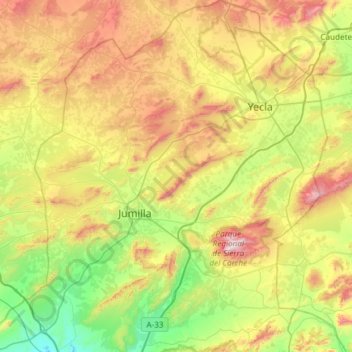
Name: Altiplano topographic map, elevation, terrain.
Location: Altiplano, Region of Murcia, Spain (38.28787 -1.49873 38.75509 -1.00157)
Average elevation: 644 m
Minimum elevation: 234 m
Maximum elevation: 1,348 m
Other topographic maps
Click on a map to view its topography, its elevation and its terrain.
Cabezo de la Plata
Spain > Region of Murcia > Campo de Cartagena y Mar Menor > Cartagena
Average elevation: 85 m
Monte Sacro
Spain > Region of Murcia > Campo de Cartagena y Mar Menor > Cartagena
Average elevation: 12 m
Alhama de Murcia
Spain > Region of Murcia > Bajo Guadalentín > Alhama de Murcia > Alhama de Murcia
Average elevation: 271 m
Murcia
Spain > Region of Murcia > Region of Murcia > Murcia
Murcia is located near the center of a low-lying fertile plain known as the huerta (orchard or vineyard) of Murcia. The Segura River and its right-hand tributary, the Guadalentín, run through the area. The city has an elevation of 43 metres (141 ft) above sea level and its municipality covers approximately…
Average elevation: 169 m
La Alberquilla
Spain > Region of Murcia > Region of Murcia > Jumilla > La Alberquilla
Average elevation: 683 m
Arroyo Tercero
Spain > Region of Murcia > Noroeste > Moratalla > Arroyo Tercero
Average elevation: 1,203 m