
Guelma topographic map
Interactive map
Click on the map to display elevation.
About this map
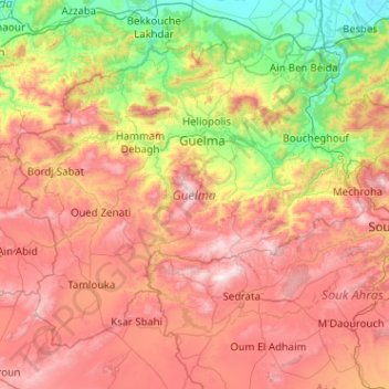
Name: Guelma topographic map, elevation, terrain.
Location: Guelma, Algeria (36.02441 6.93950 36.67360 7.95923)
Average elevation: 613 m
Minimum elevation: 4 m
Maximum elevation: 1,414 m
Other topographic maps
Click on a map to view its topography, its elevation and its terrain.
Algiers
Algeria > Algiers > Sidi M'Hamed District > Alger-Centre
The city contains the largest infrastructure facilities in the country; railway and highway connections with neighbouring cities and international links via the Houari Boumediene Airport and Algiers Ferry Terminal. Algiers possesses notable mass transit options, that includes the Algiers Metro, the city's…
Average elevation: 45 m