
Orion topographic map
Interactive map
Click on the map to display elevation.
About this map
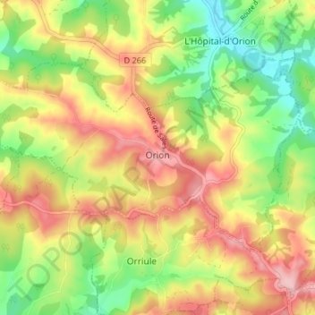
Name: Orion topographic map, elevation, terrain.
Average elevation: 156 m
Minimum elevation: 75 m
Maximum elevation: 239 m
Other topographic maps
Click on a map to view its topography, its elevation and its terrain.
Hours
France > Nouvelle-Aquitaine > Pyrénées-Atlantiques
Hours, Pau, Pyrénées-Atlantiques, Nouvelle-Aquitaine, Metropolitan France, 64420, France
Average elevation: 333 m