
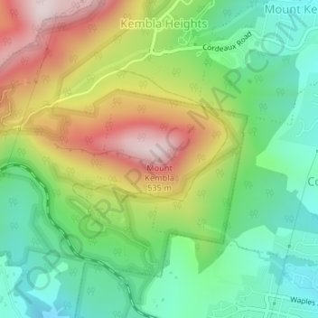
Mount Kembla topographic map
Interactive map
Click on the map to display elevation.
About this map
Name: Mount Kembla topographic map, elevation, terrain.
Average elevation: 227 m
Minimum elevation: 30 m
Maximum elevation: 528 m
The summit of Mount Kembla has an elevation of 534 metres (1,752 ft) above sea level.
Other topographic maps
Click on a map to view its topography, its elevation and its terrain.
Balgownie
Australia > New South Wales > Wollongong City Council
Balgownie, Wollongong City Council, New South Wales, 2519, Australia
Average elevation: 124 m
Dombarton
Australia > New South Wales > Wollongong City Council
Dombarton, Wollongong City Council, New South Wales, 2530, Australia
Average elevation: 262 m