
West Talaongan topographic map
Interactive map
Click on the map to display elevation.
About this map
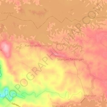
Name: West Talaongan topographic map, elevation, terrain.
Location: West Talaongan, Laguna, Calabarzon, Philippines (14.26115 121.51087 14.30115 121.55087)
Average elevation: 285 m
Minimum elevation: 182 m
Maximum elevation: 327 m
Other topographic maps
Click on a map to view its topography, its elevation and its terrain.
Caliraya Lake
Philippines > Laguna > West Talaongan
Caliraya Lake, Access Road to Surf Kamp, West Talaongan, Laguna, Calabarzon, Philippines
Average elevation: 254 m