
Sacramento County topographic map
Interactive map
Click on the map to display elevation.
Sacramento County
According to the U.S. Census Bureau, the county has a total area of 994 square miles (2,570 km2), of which 965 square miles (2,500 km2) is land and 29 square miles (75 km2) (3.0%) is water. Most of the county is at an elevation close to sea level, with some areas below sea level. The highest point in the county is Carpenter Hill at 828 feet (252 m), in the southeast part of Folsom. Major watercourses in the county include the American River, Sacramento River, Cosumnes River, a tributary of the Mokelumne River, and Dry Creek, a tributary of the Sacramento River.
About this map
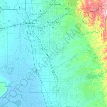
Name: Sacramento County topographic map, elevation, terrain.
Location: Sacramento County, California, United States of America (38.01827 -121.86281 38.73635 -121.02708)
Average elevation: 62 m
Minimum elevation: -8 m
Maximum elevation: 610 m
Other topographic maps
Click on a map to view its topography, its elevation and its terrain.
Hemet
United States of America > California > Hemet
Dedicated to James Simpson, Hemet City Council 1947–48, and mayor 1950 to 1966. Simpson Park is a wilderness park located in the Santa Rosa Hills southeast of Hemet with sheltered picnic area and tables, barbecues, restrooms, and hiking trails. At an elevation of 2,500 feet (760 m), it provides an expansive…
Average elevation: 508 m