
Mahatao topographic map
Interactive map
Click on the map to display elevation.
About this map
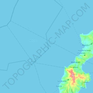
Name: Mahatao topographic map, elevation, terrain.
Location: Mahatao, Batanes, Cagayan Valley, 3901, Philippines (20.39315 121.80903 20.49530 122.01533)
Average elevation: 24 m
Minimum elevation: 0 m
Maximum elevation: 1,006 m
Other topographic maps
Click on a map to view its topography, its elevation and its terrain.
Mount Iraya
Philippines > Batanes > Basco
Iraya is a heavily forested stratovolcano, with an elevation of 1,009 metres (3,310 ft) asl, and a base diameter of 5,500 metres (18,000 ft).
Average elevation: 493 m