
Tver Oblast topographic map
Interactive map
Click on the map to display elevation.
About this map
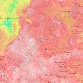
Name: Tver Oblast topographic map, elevation, terrain.
Location: Tver Oblast, Central Federal District, Russia (54.55345 32.61444 59.67345 37.73444)
Average elevation: 156 m
Minimum elevation: 15 m
Maximum elevation: 332 m
Tver Oblast as a whole is characterized by flat terrain with alternating lowlands and highlands. In the western part of the province, occupying about one-third of its area is Valdai Hills, with elevations of 200–300 m above sea level. It is surrounded by depressions, lowlands have a height of 100–150 m highest point of the area has a height of 347 m, is located on a hill Tsninsky (The top of the Valdai). The low point (61 m) - the extreme north-west area of the river's edge Kunya (Russian: Кунья) on the border with the Novgorod Oblast.
Other topographic maps
Click on a map to view its topography, its elevation and its terrain.
Kashin
Russia > Tver Oblast > Kashinsky District
Kashin, Kashinsky District, Tver Oblast, Central Federal District, Russia
Average elevation: 133 m
Фёдоровское сельское поселение
Russia > Tver Oblast > Фёдоровское сельское поселение
Фёдоровское сельское поселение, Kimrsky District, Tver Oblast, Central Federal District, 171533, Russia
Average elevation: 127 m
Батино
Russia > Tver Oblast > Батино
Батино, Kalininsky District, Tver Oblast, Central Federal District, Russia
Average elevation: 139 m
Kashinsky District
Kashinsky District, Tver Oblast, Central Federal District, Russia
Average elevation: 142 m