
Saint Petersburg topographic map
Interactive map
Click on the map to display elevation.
Saint Petersburg
The elevation of Saint Petersburg ranges from the sea level to its highest point of 175.9 m (577 ft) at the Orekhovaya Hill in the Duderhof Heights in the south. Part of the city's territory west of Liteyny Prospekt is no higher than 4 m (13 ft) above sea level, and has suffered from numerous floods. Floods in Saint Petersburg are triggered by a long wave in the Baltic Sea, caused by meteorological conditions, winds and shallowness of the Neva Bay. The five most disastrous floods occurred in 1824 (4.21 m or 13 ft 10 in above sea level, during which over 300 buildings were destroyed), 1924 (3.8 m, 12 ft 6 in), 1777 (3.21 m, 10 ft 6 in), 1955 (2.93 m, 9 ft 7 in), and 1975 (2.81 m, 9 ft 3 in). To prevent floods, the Saint Petersburg Dam has been constructed.
About this map
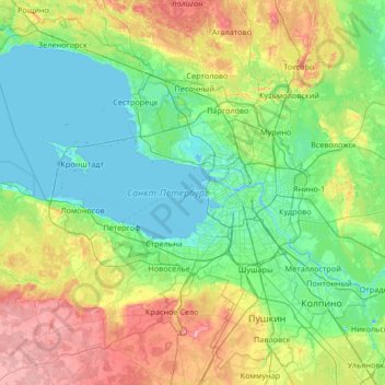
Name: Saint Petersburg topographic map, elevation, terrain.
Location: Saint Petersburg, Northwestern Federal District, Russia (59.63378 29.42576 60.24484 30.75949)
Average elevation: 40 m
Minimum elevation: -7 m
Maximum elevation: 171 m
Other topographic maps
Click on a map to view its topography, its elevation and its terrain.
Sochi
Russia > Krasnodar Krai > Resort Town of Sochi (municipal formation)
Sochi has a humid subtropical climate (Köppen climate classification Cfa), at the lower elevations. Its average annual temperature is 18.9 °C (66.0 °F) during the day and 11.5 °C (52.7 °F) at night. In the coldest months—January and February—the average temperature is about 10 °C (50 °F) during the…
Average elevation: 148 m
Ural Mountains
Russia > Khanty-Mansiysk Autonomous Okrug – Ugra > Beryozovsky District
The Ural Mountains (/ˈjʊərəl/ YOOR-əl; Russian: Ура́льские го́ры, tr. Uralskiye gory, IPA: [ʊˈralʲskʲɪjə ˈɡorɨ]; Bashkir: Урал тауҙары) or simply the Urals, are a mountain range in Eurasia that runs north-south mostly through Russia, from the coast of the Arctic Ocean to…
Average elevation: 1,435 m
Siberia
Russia > Krasnoyarsk Krai > Boguchansky Rayon
Eastern and central Sakha comprises numerous north–south mountain ranges of various ages. These mountains extend up to almost 3,000 metres (9,800 ft), but above a few hundred metres they are almost completely devoid of vegetation. The Verkhoyansk Range was extensively glaciated in the Pleistocene, but the…
Average elevation: 346 m
Mount Yamantau
Russia > Bashkortostan > Beloretsky District
Up to 1,000–1,100 m elevation, the mountain slope is covered with mixed forest, in some places with driftwood, occasional alpine meadows and rocky outcrops. Above 1,100 m elevation, there are no trees or bushes, and instead rock streams of various sizes, with grass, flowers and moss start to appear.
Average elevation: 1,334 m
Tyulyuk River
Russia > Chelyabinsk Oblast > Katav-Ivanovsky District > Tyulyuk
Average elevation: 675 m
Tunguska event
Russia > Krasnoyarsk Krai > Evenkiysky Rayon
The Tunguska event was a large explosion of between 3 and 50 megatons that occurred near the Podkamennaya Tunguska River in Yeniseysk Governorate (now Krasnoyarsk Krai), Russia, on the morning of 30 June 1908. The explosion over the sparsely populated East Siberian taiga felled a large number of trees, over an…
Average elevation: 333 m
Mount Elbrus (East Summit)
Russia > Kabardino-Balkaria > Elbrus District
As Elbrus is located in the Northern Hemisphere, the summer period takes place from June to mid-September, with an average of 50% of sunny days favorable to the ascent of the summit. However, the winds, dominated by westerly air masses, can turn violent and temperatures drop very quickly. Above 4000 meters…
Average elevation: 5,160 m
Central Caucasian Ridge
Russia > Kabardino-Balkaria > Cherek District > Verkhnyaya Balkariya
The highest and rockiest section of the range is located in its central part. Although not as high as the topmost summits of the Lateral Range to the north, the highest elevations of the Main Caucasian Range include the 5,193 meters (17,037 ft) high Shkhara, the 4,466 meters (14,652 ft) high Mount Bazardüzü…
Average elevation: 2,784 m
Fyodorovsky
Russia > Khanty-Mansiysk Autonomous Okrug – Ugra > Surgutsky District
Average elevation: 65 m