
Bydgoszcz topographic map
Interactive map
Click on the map to display elevation.
About this map
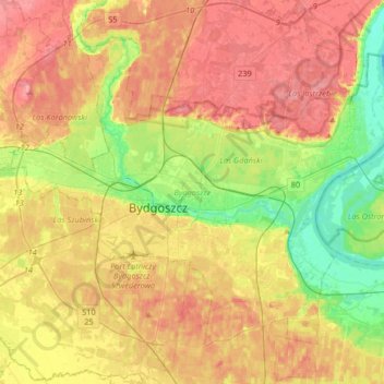
Name: Bydgoszcz topographic map, elevation, terrain.
Location: Bydgoszcz, Kuyavian-Pomeranian Voivodeship, Poland (53.05011 17.87417 53.20934 18.20171)
Average elevation: 69 m
Minimum elevation: 24 m
Maximum elevation: 109 m
The etymology of the German name of the town developed later and derives from the river Brahe (Brda in Polish), on banks of which the place sits, and berg, elevation, mount(ain), combined to 'Brahenberg', with 'a' pronounced in East Pomeranian Low German rather like 'å', later contracted to Bromberg, dropping the weak 'h', with the 'n' assimilated as 'm' to the following labial sound 'b'.
Other topographic maps
Click on a map to view its topography, its elevation and its terrain.
Włocławek
Poland > Kuyavian-Pomeranian Voivodeship
Włocławek, Kuyavian-Pomeranian Voivodeship, Poland
Average elevation: 73 m
Świecie County
Poland > Kuyavian-Pomeranian Voivodeship
Świecie County, Kuyavian-Pomeranian Voivodeship, Poland
Average elevation: 79 m
Bydgoszcz County
Poland > Kuyavian-Pomeranian Voivodeship
Bydgoszcz County, Kuyavian-Pomeranian Voivodeship, Poland
Average elevation: 91 m
Lipno
Poland > Kuyavian-Pomeranian Voivodeship > Lipno
Lipno, Lipno County, Kuyavian-Pomeranian Voivodeship, Poland
Average elevation: 103 m
Świecie
Poland > Kuyavian-Pomeranian Voivodeship > Świecie
Świecie, gmina Świecie, powiat świecki, Kuyavian-Pomeranian Voivodeship, 86-101, Poland
Average elevation: 44 m