
Ibbenbüren topographic map
Interactive map
Click on the map to display elevation.
About this map
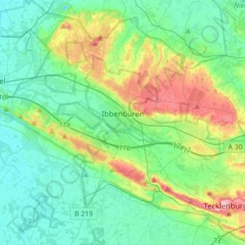
Name: Ibbenbüren topographic map, elevation, terrain.
Location: Ibbenbüren, Kreis Steinfurt, North Rhine-Westphalia, Germany (52.19808 7.60364 52.34606 7.84297)
Average elevation: 81 m
Minimum elevation: 39 m
Maximum elevation: 202 m
Other topographic maps
Click on a map to view its topography, its elevation and its terrain.
Lengerich
Germany > North Rhine-Westphalia > Kreis Steinfurt > Lengerich > Lengerich
Average elevation: 91 m