
Luotian topographic map
Interactive map
Click on the map to display elevation.
About this map
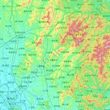
Name: Luotian topographic map, elevation, terrain.
Location: Luotian, Huanggang City, Hubei, PRC (30.32081 114.82826 31.60081 116.10826)
Average elevation: 296 m
Minimum elevation: 8 m
Maximum elevation: 1,729 m
Other topographic maps
Click on a map to view its topography, its elevation and its terrain.
Shennongjia
PRC > Hubei > Shennongjia
Shennongjia, Shennongjia Forestry District, Hubei, PRC
Average elevation: 1,408 m