
Clackamas County topographic map
Interactive map
Click on the map to display elevation.
About this map
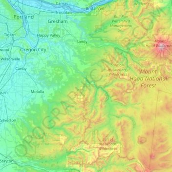
Name: Clackamas County topographic map, elevation, terrain.
Location: Clackamas County, Oregon, United States of America (44.88571 -122.86800 45.46167 -121.65149)
Average elevation: 660 m
Minimum elevation: -1 m
Maximum elevation: 3,392 m
Other topographic maps
Click on a map to view its topography, its elevation and its terrain.
Lane County
United States of America > Oregon
Lane County, Oregon, United States of America
Average elevation: 712 m
Multnomah County
United States of America > Oregon
Multnomah County, Oregon, United States of America
Average elevation: 334 m
Klamath County
United States of America > Oregon
Klamath County, Oregon, United States of America
Average elevation: 1,420 m
Tillamook County
United States of America > Oregon
Tillamook County, Oregon, United States of America
Average elevation: 236 m