
Tando topographic map
Interactive map
Click on the map to display elevation.
About this map
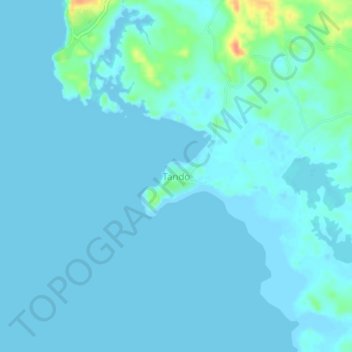
Name: Tando topographic map, elevation, terrain.
Average elevation: 5 m
Minimum elevation: -2 m
Maximum elevation: 45 m
Other topographic maps
Click on a map to view its topography, its elevation and its terrain.
Yeto Island
Philippines > Guimaras > Nueva Valencia > Panobolon
Yeto Island, Panobolon, Yato, Nueva Valencia, Guimaras, Western Visayas, Philippines
Average elevation: 3 m
Tiniguiban Island
Philippines > Guimaras > Nueva Valencia
Tiniguiban Island, Nueva Valencia, Guimaras, Western Visayas, Philippines
Average elevation: 2 m